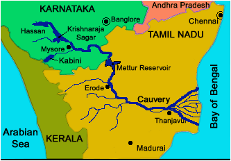
The Cauvery (also spelt as ‘Kaveri’), known as ‘Ponni’ in Tamil, is the fourth-largest river in south India. The Cauvery river is considered a sacred river of southern India, rising on Brahmagiri Hill in the Western Ghats in Coorg district of Karnataka state, flowing in a south-easterly direction for 475 mi (765 km) through Karnataka and Tamil Nadu states, and descending the Eastern Ghats in a series of great falls. Before emptying into the Bay of Bengal south of Cuddalore, Tamil Nadu, it breaks into a large number of distributaries describing a wide delta called the “garden of southern India.” Known to devout Hindus as Daksina Ganga (Ganges of the South), it is celebrated for its scenery and sanctity in Tamil literature, and its entire course is considered holy ground. The river is also important for its irrigation-canal projects.
Cauvery river in Karnataka
Its uppermost course is tortuous with a rocky bed and high banks under luxuriant vegetation. After passing through a narrow gorge and tumbling 60-80 ft (18-24 m) in the rapids of Chunchankatte, the river widens to 900-1,200 ft across the Karnataka plateau. There, its flow is interrupted by a number of anicuts or weirs. At the Krishnaraja Sagara, the Cauvery is joined by two tributaries, the Hemavati and Lakshmantirtha, and dammed for irrigation, forming a 12-sq-mi (31-sq-km) reservoir.
In Karnataka, the river bifurcates twice, forming the sacred islands of Srirangapatnam and Sivasamudram, 50 mi apart. Around Sivasamudram are the scenic Sivasamudram Falls, comprising two series of rapids, Bhar Chukki and Gagana Chukki, plunging 320 ft and reaching a width of 1,000 ft in the rainy season. The falls supply hydroelectric power to Mysore, Bangalore, and the Kolar Gold Fields, more than 100 mi away.
Map of the Cauvery River
Cauvery river in Tamil Nadu
Upon entering Tamil Nadu, the Cauvery continues through a series of twisted wild gorges until it reaches Hogenakal Falls and flows through a straight, narrow gorge near Salem. There, the Mettur Dam, 5,300 ft long and 176 ft high, impounds a lake (Stanley Reservoir) of 60 sq mi. The Mettur Project, completed in 1934, created an important agricultural and industrial area by improving irrigation and providing hydropower.
After sweeping past the historic rock of Tiruchchirappalli (Trichinopoly), the Cauvery breaks at Srirangam Island, a main pilgrimage centre. There in Thanjavur (Tanjore) district of Tamil Nadu state, its braided and extensively irrigated deltaic region of about 4,000 sq mi begins. The Grand Anicut was built in the 2nd century at the point where the river divides. A second anicut (1836-38) across the Coleroon, the northern and larger channel, saved the old system from silting and extended irrigation. The open roadsteads of Nagappattinam and Karikal are on the seaward side of the delta. The only navigation on any part of the Cauvery course is in basketwork boats. Its main tributaries are the Kabbani, Amaravati, Noyil, and Bhavani rivers.
Are your Indian relatives or parents visiting USA, you and friends traveling abroad. If so, have you purchased visitor insurance? Quote, review, compare and buy visitors insurance online.